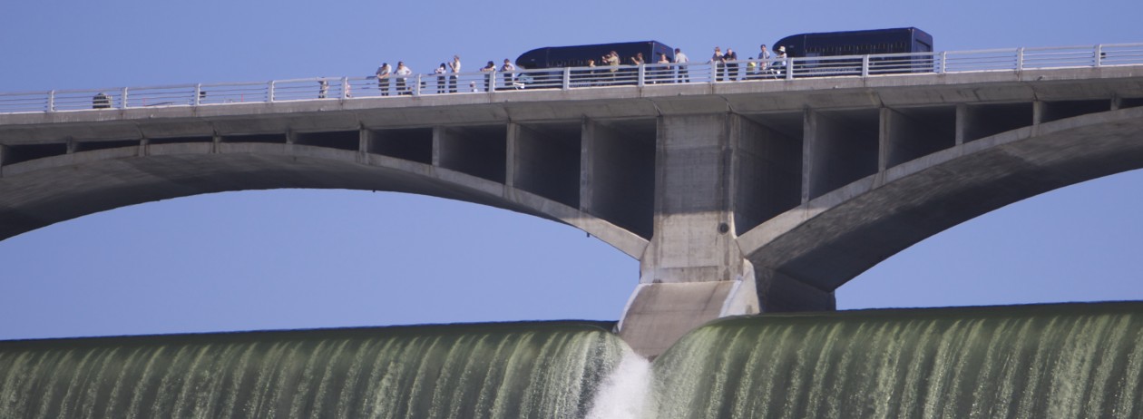
If you’re lucky, usually in the spring, you might get to see the rare and amazing site of water falling down Grand Coulee Dam’s huge spillway about 300 feet to the river below.
Some years this doesn’t happen at all, which is the way most who “operate” the Columbia River prefer it.
Today, the rest of us get our wish. They’ve been “spilling” for the last two days, the result of too much runoff from the snow-packed mountains upstream, which is carefully and continuously measured to avoid flooding downstream.
The Bureau appears to be holding the level of Lake Roosevelt behind the dam at about 1267. Full is 1290 (feet above sea level, that is).
In the photo, less than 10 percent of the River’s flow is coming over the top. The rest of the 173,000 cubic feet per second is flowing through the dam, some of it making electricity.
You can check for yourself how much is currently spilling or flowing through and what the levels of the water are with is link.
Last Thursday, the official forecast was that the lake would come up over the next week to the mid 1270s. Here’s a graph of this years lake levels compared to last year’s.
For reasons unknown to me at the moment, the USBR is letting water flow over the top of Grand Coulee Dam right now. This is a fairly unusual event. That’s not just water, it’s money running over the top, in the form of revenue foregone by the BPA, which can’t sell electricity the dam doesn’t produce with that water power.
If you have a chance, pop down and see it.
The dam is almost a mile across, and the spill is about 300 feet.
Update
Seems that Lake Roosevelt has to drop right now to meet flood control goals. We wouldn’t want Portland to flood, after all. Here is info about current lake operations the USBR published yesterday:
The elevation of Lake Roosevelt was 1280.4 at 10 a.m. on April 9.
It is antipated the elevation will remain around elevation 1280.0 in order to reach the Biological Opinion operating objective of 1279.9 by April 10. Currently, Grand Coulee Dam is being operated to meet flood control elevations.
The flood control levels are the maximum elevation for Lake Roosevelt. Other factors such as power demand or supplying water downstream for fish can result in elevations under the flood control elevations.
The current flood control elevation is as follows:
April 30 – 1258.5 feet
This is only a prediction and can change due to weather events, power demand or other unforeseen power emergencies.
Lake level forecasts are updated by 3 p.m. each day. Please call 1-800-824-4916 for the updated forecast.